South Central
Airlines ’63
(image copyright Bjorn Larsson www.timetableimages.com)
South Central Airlines
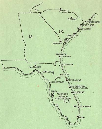
South Central Airlines were formed in
October ’63 to act as a feeder liner service to airports served by main airlines
as their aircraft increased in size and became less able to handle smaller
airports. The services ranged from Charlotte, North Carolina to Miami, Florida.
The fleet consisted of Beech D-18S and
a Piper Aztec. A timetable illustration suggests that the Beechcrafts included the
H18 with tricycle undercarriage.
After a crash in February ’64, which
proved to be as a result of overloading and tail-heavy weight distribution, the
airline lost public confidence. It ceased operation in July ’64.
The flights below came from the November
’63 timetable from www.timetableimages.com
.
Good luck making sense of the
connections.
Charlotte – Tampa (409/500)
|
Heading |
Distance |
Down |
City
Name |
ICAO |
Up |
Heading |
Distance |
|
141 |
0 |
1850 |
Charlotte |
KCLT |
1835 |
- |
86.2 |
|
194 |
86.2 |
1940 |
Florence |
KFLO |
1750 |
321 |
90.2 |
|
245 |
90.2 |
2025 |
Charleston |
KJZI |
1650 |
014 |
69.8 |
|
- |
69.8 |
2100 |
Savannah |
KSAV |
1600 |
065 |
59.4 |
|
|
|
Switch 503 |
Brunswick |
KSSI |
1455 |
014 |
42.3 |
|
|
|
|
Jacksonville |
KJAX |
1420 |
025 |
50.1 |
|
|
|
|
Palatka |
28J |
Flag |
003 |
30.4 |
|
|
|
|
Gainesville |
KGNV |
1320 |
096 |
40.0 |
|
|
|
|
Ocala |
FL61 |
1250 |
359 |
63.1 |
|
|
|
|
Lakeland |
KLAL |
1210 |
354 |
27.3 |
|
|
|
|
Tampa |
KTPA |
1140 |
091 |
0 |
Tallahassee – Miami (703/700)
|
Heading |
Distance |
Down |
City
Name |
ICAO |
Up |
Heading |
Distance |
|
114 |
0 |
1415 |
Tallahassee |
KTLH |
1345 |
- |
116.0 |
|
178 |
116.0 |
1520 |
Gainesville |
KGNV |
1250 |
294 |
40.0 |
|
173 |
40.0 |
1550 |
Ocala |
FL61 |
1220 |
359 |
63.1 |
|
105 |
63.1 |
1635 |
Lakeland |
KLAL |
1145 |
354 |
12.8 |
|
133 |
12.8 |
1700 |
Bartow |
KBOW |
1120 |
285 |
117.5 |
|
195 |
117.5 |
1810 |
West
Palm Beach |
KPBI |
1010 |
313 |
54.4 |
|
- |
54.4 |
1850 |
Miami |
KTPA |
0930 |
015 |
0 |
Tallahassee – Tampa (803/804)
|
Heading |
Distance |
Down |
City
Name |
ICAO |
Up |
Heading |
Distance |
|
090 |
0 |
0840 |
Tallahassee |
KTLH |
1740 |
- |
137.8 |
|
183 |
137.8 |
1010 |
Jacksonville |
KJAX |
1625 |
270 |
85.4 |
|
134 |
50.1 |
Flag |
Palatka |
28J |
- |
- |
- |
|
165 |
43.7 |
1105 |
Daytona |
KDAB |
1525 |
341 |
42.2 |
|
165 |
42.2 |
1135 |
Cape
Canaveral |
KTIX |
1455 |
345 |
26.0 |
|
268 |
26.0 |
1200 |
Melbourne |
KMLB |
1430 |
345 |
73.0 |
|
270 |
73.0 |
1245 |
Lakeland |
KLAL |
1345 |
088 |
27.3 |
|
- |
27.3 |
1300 |
Tampa |
KTPA |
1315 |
091 |
0 |
Wilmington – Tampa (503/502)
|
Heading |
Distance |
Down |
City
Name |
ICAO |
Up |
Heading |
Distance |
|
243 |
0 |
1000 |
Wilmington |
KILM |
1210 |
- |
49.2 |
|
231 |
49.2 |
Flag |
Myrtle
Beach |
KCRE |
Flag |
063 |
42.3 |
|
229 |
42.3 |
Flag |
Georgetown |
KGGE |
Flag |
051 |
50.3 |
|
245 |
50.3 |
1410 |
Charleston |
KJZI |
1110 |
049 |
69.8 |
|
194 |
69.8 |
1500 |
Savannah |
KSAV |
1020 |
065 |
59.4 |
|
204 |
59.4 |
1535 |
Brunswick |
KSSI |
0940 |
014 |
42.3 |
|
183 |
42.3 |
1615 |
Jacksonville |
KJAX |
0905 |
025 |
50.1 |
|
277 |
50.1 |
Flag |
Palatka |
28J |
Flag |
003 |
30.4 |
|
178 |
30.4 |
1710 |
Gainesville |
KGNV |
0745 |
096 |
40.0 |
|
197 |
40.0 |
1745 |
Ocala |
FL61 |
0715 |
359 |
63.1 |
|
- |
- |
- |
Lakeland |
KLAL |
0630 |
354 |
0 |
|
- |
65.2 |
1820 |
Tampa |
KTPA |
|
|
|
Flight Simulator Files
There are no South Central Airlines schemes available. Versions
of the D-18S by Milton Shupe are available on most flight simulator sites.
(image copyright Bjorn Larsson www.timetableimages.com)