

Bluegrass
Airlines, September 2009
QIKIQTANI COMMUNITIES
TOUR
By Allan Lowson
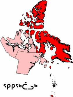
Qikiqtaaluk Region or Baffin Region is
an administrative region of
The region
consists of Baffin Island, the Belcher Islands, Akimiski Island, Mansel Island,
Prince Charles Island, Bylot Island, Devon Island, Cornwallis Island, Bathurst
Island, Amund Ringnes Island, Ellef Ringnes Island, Axel Heiberg Island,
Ellesmere Island, the Melville Peninsula, the eastern part of Melville Island,
and the northern parts of Prince of Wales Island, and Somerset Island, plus
smaller islands in between. The regional seat is Iqaluit (population 6,184). It
contains both the northernmost and southernmost areas of the territory.
Before 1999,
Qikiqtaaluk Region existed under slightly different boundaries as Baffin
Region,
Given the
scale of the region, we will be “just” touring the communities on Baffin Island
together with the two on
The Canadian North scheme is available at www.flightsim.com as anxcgrgo.zip and you will need the base model which is contained in either dw8qnaha.zip or dwd8q200.zip, but you can fly anything you like on this tour.
It would make life a bit easier if you are able to use the NDBs along the way. As we are so close to the Magnetic North Pole, you will need to keep an eye on your course between communities. A constant magnetic heading will not take you where you expect to go. Following the NDB needle will be more reliable. Only one airfield, Artic Bay CJX7 lacks a NDB and it is just 7.5nm along the peninsula from Nanisivik CYSR. The total length of this tour is 1606 nm, so something faster than a Cessna 172 may be advisable if you want to visit all the communities!
If desired, you may download an FS9 flight plan: here
|
Community Name |
ICAO |
Heading |
Distance |
NDB |
IQALUIT
|
CYFB |
254 |
0 |
YFY 204.0 |
|
KIMMIRUT |
CYLC |
335 |
65.0 |
YLC 277.0 |
|
|
CYTE |
016 |
195.8 |
YTE 332.0 |
|
|
CYUX |
027 |
294.9 |
UX 378.0 |
|
IGLOOLIK |
CYGT |
033 |
37.4 |
YGT 241.0 |
ARTIC
BAY
|
CJX7 |
162 |
227.0 |
YSR 382.0 |
|
NANISIVIK |
CYSR |
157 |
7.5 |
YSR 382.0 |
|
POND INLET |
CYIO |
184 |
119.0 |
YIO 214.0 |
|
|
CYCY |
204 |
222.0 |
YCY 256.0 |
|
QIKIQTARJUAG |
CYVM |
253 |
200.9 |
YJI 237.0 |
PANGNIRTUNG
|
CYXP |
252 |
93.0 |
YXP 218.0 |
|
IQALUIT |
CYFB |
0 |
160.6 |
YFY 204.0 |