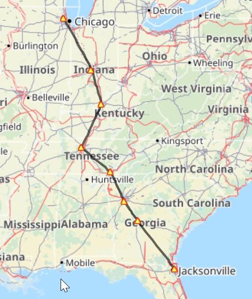
AM10
Route 1934
This route takes
us along AM10, using modern airfields where the
original ones cannot be found.
This route was operated by Eastern airlines in 1934 using Douglas DC-2
aircraft.
AM10 Route 1934
|
Heading Down |
Distance |
ICAO |
Airfield |
City |
Heading Up |
|
151° |
0 |
KORD
|
Chicago-O'Hare Intl
|
Chicago, IL
|
-
|
|
166° |
154.1 nm |
KIND
|
Indianapolis
Intl |
Indianapolis, IN |
334° |
|
208° |
96.2 nm |
KSDF
|
Louisville
Intl-Standiford |
Louisville, KY |
347° |
|
131° |
131.6 nm |
KJWN
|
Tune |
Nashville, TN |
025° |
|
157° |
107.1 nm |
KCHA
|
Lovell |
Chattanooga, TN |
313° |
|
149° |
92.1 nm |
KATL
|
Hartsfield
- Jackson |
Atlanta, GA |
339° |
|
145° |
69 nm |
KMCN
|
Middle
Georgia Regl |
Macon, GA |
329° |
|
- |
178.6 nm |
KCRG
|
Craig Mun |
Jacksonville, FL |
327° |
|
Total |
828.7nm |
|
|
|
|
AM10 Route Map