

October 2006
Dedication of the
Roy Franklin Terminal
A pilots
remembrances of the Island flights.
Roy
Franklin's book "Island Bush Pilot"
The terminal
at
In FS 9 there
are many airports and seaplane bases available to fly between.
|
Code |
Airport |
Island |
Runways |
Length |
Type |
Elevation |
|
21H |
Skyline |
(Anacortes) |
SEW/MWW |
5000’ |
Water |
0’ |
|
74S |
Anacortes |
(Anacortes) |
18/36 |
3015’ |
Asphalt |
239’ |
|
38WA |
|
Blakely Isl |
38736 |
2200’ |
Asphalt |
65’ |
|
78WA |
|
Center Isl |
17/35 |
1600’ |
Grass |
114’ |
|
WN07 |
|
|
15/33 |
2550’ |
Concrete |
391’ |
|
WA18 |
Decatur/Jones |
|
1/19 |
1500’ |
Grass |
124’ |
|
WA58 |
|
Eliza Isl |
SE/NW |
1500’ |
Grass |
6’ |
|
WA93 |
|
Eliza Isl |
16/34 |
1500’ |
Grass |
6’ |
|
WA81 |
Fishermans Bay/Lps |
Lopez Isl |
5W/33W |
4000’ |
Water |
0’ |
|
WA81 |
Fishermans Bay/Lps |
Lopez Isl |
14W/32W |
2500’ |
Water |
0’ |
|
S31 |
|
Lopez Isl |
16/34 |
2900’ |
Asphalt |
200’ |
|
4WA4 |
Windsock |
Lopez Isl |
2/20 |
1850’ |
Grass |
29’ |
|
4WA5 |
Millers Field |
Lummi Isl |
14/32 |
1650’ |
Grass |
170’ |
|
WA35 |
|
Orcas Isl |
12/30 |
1200’ |
Grass |
219’ |
|
KORS |
|
Orcas Isl |
16/34 |
2900’ |
Asphalt |
29’ |
|
W49 |
|
Orcas Isl |
7W/25W |
2500’ |
Water |
0’ |
|
W49 |
|
Orcas Isl |
16W/34W |
10000’ |
Water |
0’ |
|
WA83 |
Westsound/WSY |
Orcas Isl |
10W/28W |
4000’ |
Water |
0’ |
|
WA83 |
Westsound/WSY |
Orcas Isl |
18W/36W |
500’ |
Water |
0’ |
|
KFHR |
|
San Jaun Isl |
16/34 |
3398’ |
Asphalt |
75’ |
|
1WA9 |
Friday West |
San Jaun Isl |
15/33 |
2100’ |
Gravel |
150’ |
|
61WA |
Burden Field |
|
E/W |
2500’ |
Grass |
49’ |
|
W33 |
|
|
3W/21W |
10000’ |
Water |
0’ |
|
W33 |
|
|
12W/30W |
6000’ |
Water |
0’ |
|
WA09 |
|
|
6/24 |
4300’ |
Asphalt |
98’ |
|
W39 |
|
|
SEW/NWW |
2500’ |
Water |
0’ |
|
W39 |
|
|
NEW/SWW |
5000’ |
Water |
0’ |
|
GWA5 |
Winding Farm |
Shaw Isl |
18/36 |
1000’ |
Grass |
59’ |
|
7WA5 |
|
Stuart Isl |
9/27 |
2000’ |
Grass |
9’ |
|
2WA3 |
Stuart Island West |
Stuart Isl |
9/27 |
1560’ |
Dirt |
200’ |
|
90WA |
Waldronaire |
Waldron Isl |
14/32 |
2700’ |
Grass |
141’ |
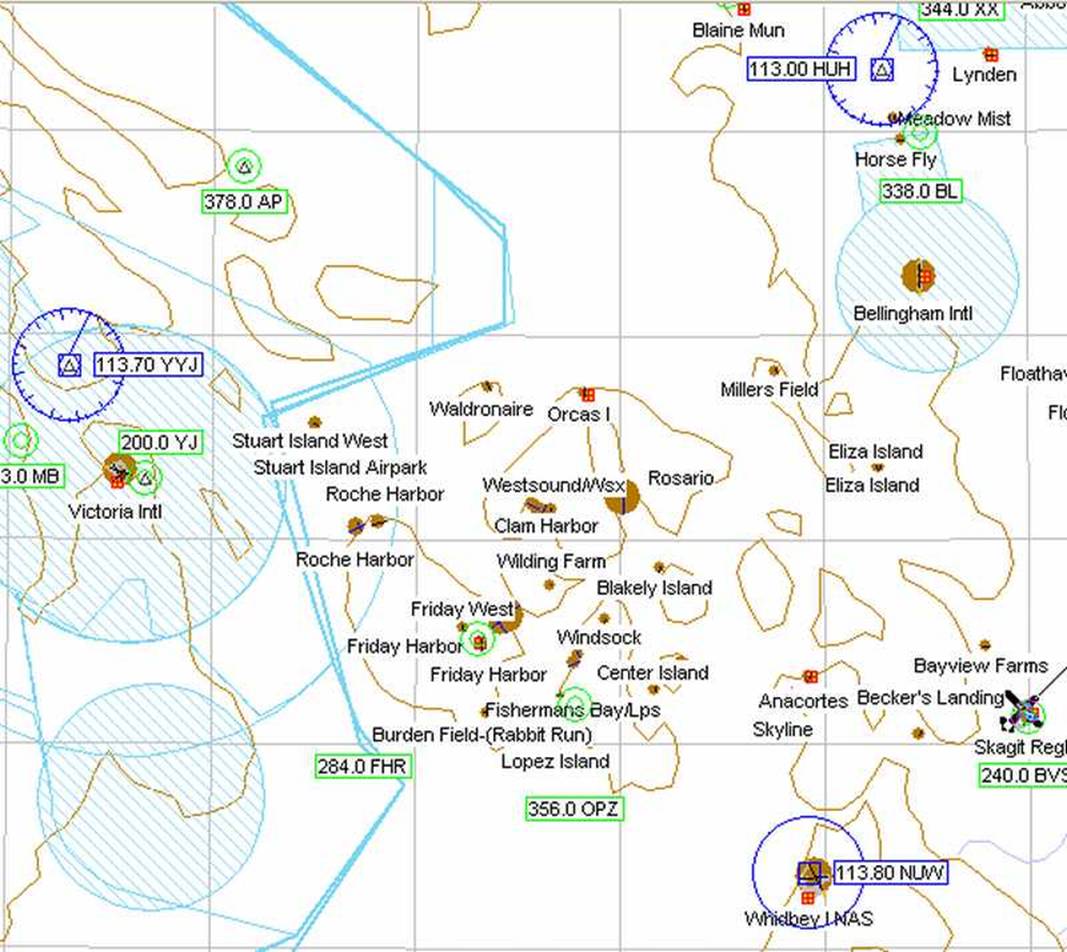
Toughman Challenge #19
These flights are all short. Take
off climb to 1500’ or less and look for the destination airport.
The heading shown is the direct
route. If the destination runway is not suitable
for a straight in approach you will want to fly with a heading 30 to 60 degrees
offset. i.e. if the chart shows a
heading of 60deg and the runway will be
1, you would fly a heading (base leg) of 100 deg and watch for the airport to
your left. Navigation aids are not needed. Usually you are hopping from one island to
the next.
|
From: |
To: |
Heading |
Distance |
|
|
KFHR |
74S |
75 deg |
14.5 nm |
|
|
74S |
WA58 |
357 deg |
9.7 nm |
Note: #6 |
|
WA58 |
4WA5 |
293 deg |
6.3 nm |
|
|
4WA5 |
KORS |
242 deg |
8.4 nm |
|
|
KORS |
90WA |
252 deg |
4.3 nm |
Note: #1 |
|
90WA |
2WA3 |
237 deg |
7.8 nm |
Note: #2 |
|
2WA3 |
WA09 |
137 deg |
3.9 nm |
|
|
WA09 |
KFHR |
119 deg |
7.1 nm |
|
|
KFHR |
WA35 |
5 deg |
6.8 nm |
Note: #3 |
|
WA35 |
6WA5 |
159 deg |
3.4 nm |
Note: #4 |
|
6WA5 |
38WA |
60 deg |
4.9 nm |
|
|
38WA |
S31 |
197 deg |
7.3 nm |
|
|
S31 |
78WA |
63 deg |
4.2 nm |
Note: #5 |
|
78WA |
WN07 |
31 deg |
0.9 nm |
|
|
WN07 |
74S |
70 deg |
6.0 nm |
|
Note:1 Waldronaire 90WA is hard to
see. Just look for a grass field. The runway is 300 ft wide!
Note:2
Note:3 The far end of RW30 ends
on a hill just east of a little notch in
the bay.
Note:4 RW18 is just south of the
south-western corner of a U-Shaped bay.
Note:5 Runway sits on a hill in
the middle of a very small island.
Note:6 Eliza Island is just to the
east of the southern tip of mountainous
My schedule: I left Friday Harbor at 7:15am and arrived
Anacotes at 7:30 Left Anacortes at 7:45
and stopped at Eliza Island at 7:54, Millers Field at 8:04 and arrived at Orcas
at 8:14 I left Orcas at 8:30am and
stopped at Walronaire at 8:36, Stewart Island west at 8:45, Roche Harbor at
8:52 and arrived at Friday Harbor at 9:01am.
After a break, while the postmaster
sorted all the mail I left Friday Harbor at 9:30am and stopped at Clam Harbor
at 9:38, Wilding Farm at 9:46, Blakley Island at 9:54 and arrived at Lopez Island
at 10:02 All of the preceding flights
were in a SR-7 Stinson.
Using a
Screenshots of some of the approaches
will be on the Screen Shots page until
November 1, 2006